Jump to the bibliography.
Questions about sources
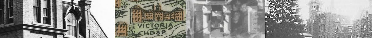
 |
| The 1907 Fire Insurance Plan, courtesy of Donald Lafreniere. |
- The 1907 Fire Insurance Plan, from which the HGIS is based, has several paste-overs that block out residences. These paste-overs are clearly not from 1907, since they represent buildings like the Western University Medical School, which wasn't built until 1921. Unfortunately it is impossible to know what the paste-overs have been...well, pasted over!
- The 1958 Fire Insurance Plan sheet only showed the hospital, not the surrounding area. Later Fire Insurance Plans more often showed industrial or commercial areas rather than residences.
- These layers were based off of aerial photos. Aerial photos are problematic for several reasons. They can be grainy and blurry, which sometimes makes it difficult to know where buildings begin and end. The flight angle, scale of photos, and curvature of the earth can cause distortion, which is carried over into the HGIS. Trees and shadows can also make tracing the aerial photos difficult. Unfortunately, there were no recent maps available which showed the building footprints more accurately.
 |
| A 2001 aerial photo, courtesy of the Serge A. Sauer Map Library. |
- Even when minimal changes are made to the buildings, layers don't always line up from layer to layer. The main reason for this is that not all maps are created equally. Historic maps have varying degrees of precision, and photographs are not always easy to trace. The result is seen in spatial shifts of building footprints from layer to layer. Distortion can also be caused by the ease or difficulty with which historical material was able to be traced.
- The Isolation Hospital is identified in the 1915-1925 HGIS, even though it was built in 1910. This is because the HGIS for the 1899-1914 period was based on a map from 1907, which of course did not show the isolation hospital. In cases like this, the buildings in question are discussed in the appropriate period with a blue marker, and identified on the following map with an orange marker.
Bibliography
Documents
London Free Press.
London Health Sciences Centre. "1990-2011: Restructuring Healthcare in London." Celebrating South Street Hospital. Last modified October 13, 2011. Accessed October 22, 2013.
Nightingale, Florence. Notes on Hospitals. 3rd edition. London: Longman, 1863. Accessed 9 November, 2013.
Seaborn, Edwin. The March of Medicine in Western Ontario. Toronto: Ryerson Press, 1944.
Sullivan, John R. and Norman R. Ball. Growing to serve…: a history of Victoria Hospital, London, Ontario. London, Ontario: Victoria Hospital Corporation, 1985. Accessed October 22, 2013.
Tausky, Nancy Z. Cultural Heritage Assessment: Buildings in the South Street Hospital Complex, London, Ontario. London, Ontario: the City of London, May 2011. Accessed October 31, 2013.
Thompson, John D. and Grace Goldin. The Hospital: A Social and Architectural History. New Haven: Yale University Press, 1975.
Images, Maps and Geospatial Data
“City Hospital, London, Ontario.” Black and white photograph. Ca. 1875. From the Ivey Family London Room, London Public Library, London Public Library Image Gallery. Accessed October 22, 2013.
City of London Digital Mapping Data Distribution Disc, version 2013.00 [computer file]. London, Ontario: The Corporation of the City of London, 2012.
Goad, Chas A. “Sheet 28 – Insurance Plan of the City of London, Ontario – 1881, Revised 1888.” Archives and Research Collections Centre, Western University. Georeferenced plan courtesy of Professor Donald LaFreniere, Human Environments Analysis Laboratory, Western University.
Goad, Chas A. “Sheet 28 – Insurance Plan of the City of London, Ontario – 1892, Revised 1907.” Archives and Research Collections Centre, Western University. Georeferenced plan courtesy of Professor Donald LaFreniere, Human Environments Analysis Laboratory, Western University.
Goad, Chas A. “Sheet 28 – Insurance Plan of the City of London, Ontario – 1912, Revised 1915.” Archives and Research Collections Centre, Western University. Georeferenced plan courtesy of Professor Donald LaFreniere, Human Environments Analysis Laboratory, Western University.
Goad, Chas A. “Sheet 28 – Insurance Plan of the City of London, Ontario – 1912, Revised 1922.” Archives and Research Collections Centre, Western University. Georeferenced plan courtesy of Professor Donald LaFreniere, Human Environments Analysis Laboratory, Western University.
"Sheet 60 - Insurance Plan of the City of London, Ontario - 1958." Archives and Research Collections Centre, Western University. Georeferenced plan courtesy of Professor Donald LaFreniere, Human Environments Analysis Laboratory, Western University.
"London 1967 Air Photos - Line 2, Photo 139." From the Serge A. Sauer Map Library, Western University.
"London 1982 Air Photos - Photo 29." From the Serge A. Sauer Map Library, Western University.
"London 2001 Air Photos - Line 9, Photo 215." From the Serge A. Sauer Map Library, Western University.
London Health Sciences Centre. “CPav_3babies.” Black and white photograph. No date. Celebrating South Street Hospital. Last modified October 13, 2011. Accessed October 22, 2013.
---. “IMG_0006.” Black and white photograph. 1885-1886. Celebrating South Street Hospital. Last modified October 13, 2011.
---. "IMG_0007." Black and white aerial photograph. No date. Celebrating South Street Hospital. Last modified October 13, 2011. Accessed December 1, 2013.
---. “Nurses_1932.” Black and white photograph. 1932. Celebrating South Street Hospital. Last modified October 13, 2011. Accessed October 22, 2013.
---. “Main_1920_isolation.” Black and white photograph. No date. Celebrating South Street Hospital. Last modified October 13, 2011. Accessed October 22, 2013.
---. "Main_1967_Eldorado." Black and white photograph. No date. Celebrating South Street Hospital. Last modified October 13, 2011. Accessed December 1, 2013.
---. "NT_May2008-01." Colour photograph. Circa May 2008. Celebrating South Street Hospital. Last modified October 13, 2011. Accessed December 1, 2013.
---. "SSC-Move-060." Colour photograph. Circa June 12, 2005. Celebrating South Street Hospital. Last modified October 13, 2011. Accessed December 1, 2013.
---. “SSH_0002.” Black and white photograph. No date. Celebrating South Street Hospital. Last modified October 13, 2011. Accessed October 22, 2013.
---. "SSHMain_009." Black and white aerial photograph. No date. Celebrating South Street Hospital. Last modified October 13, 2011. Accessed December 1, 2013.
---. “SSHMain_021_ca1875.” Sketch. Ca. 1875. Celebrating South Street Hospital. Last modified October 13, 2011. Accessed October 22, 2013.
---. “SSHMain_030b.” Black and white photograph. 1923. Celebrating South Street Hospital. Last modified October 13, 2011. Accessed October 22, 2013.
---. “WMCH_front1.” Black and white photograph. No date. Celebrating South Street Hospital. Last modified October 13, 2011. Accessed October 22, 2013.
---. “WMCH_Layinggirl.” Black and white photograph. No date. Celebrating South Street Hospital. Last modified October 13, 2011. Accessed October 22, 2013.
---. “WMCH_rollingcart_1925.” Black and white photograph. Ca. 1925. Celebrating South Street Hospital. Last modified October 13, 2011. Accessed October 22, 2013.
Other Consulted Sources
Bird’s-eye view from Ontario’s History in Maps. Lithograph. Toronto: Toronto Lithographic Company, 1892. From Serge A. Sauer Map Library, Western University, City of London Historical Maps.
Lapointe, Kelly. “Canadian Standards Association releases hospital construction protocol.” Daily Commercial News, 14 December 2011. Accessed 7 November 2013.
“London 1922 Air Photos – Line R4, Photo 45.” Scale: 1:3125 (approx.). Captured Spring-Summer 1922. Department of Land and Forests. City of London Aerial Photo Indexes – 1922. Western University. Accessed October 22, 2013.
“London 1922 Air Photos – Line R4, Photo 46.” Scale: 1:3125 (approx.). Captured Spring-Summer 1922. Department of Land and Forests. City of London Aerial Photo Indexes – 1922. Western University. Accessed October 22, 2013.
“London 1942 Air Photos – Line 18, Photo 9.” Scale: 1:12,000 (approx.). Captured Summer 1942. Department of Land and Forests. City of London Aerial Photo Indexes – 1942. Western University. Accessed November 10, 2013.
"London 1960 Air Photos - Line A17030, Photo 19." From the Serge A. Sauer Map Library, Western University.
"London 1993 Air Photos - Line 12, Photo 18." From the Serge A. Sauer Map Library, Western University.
London Advertiser.
London Evening Advertiser.
London Health Sciences Centre. “1886-1899: Celebrating a Diamond Jubilee.” Celebrating South Street Hospital. Last modified October 13, 2011. Accessed October 22, 2013.
---. “1874-1885: A Centre for Care, Education and Training." Celebrating South Street Hospital. Last modified October 13, 2011. Accessed October 22, 2013.
---. “1900-1909: The Adam Beck Era.” Celebrating South Street Hospital. Last modified October 13, 2011. Accessed October 22, 2013.
---. “1911-1929: World War I and the Optimistic Twenties.” Celebrating South Street Hospital. Last modified October 13, 2011. Accessed October 22, 2013.
---. “1930-1945: Depression and WWII.” Celebrating South Street Hospital. Last modified October 13, 2011. Accessed October 22, 2013.
---. "1946-1969: The Post War Years." Celebrating South Street Hospital. Last modified October 13, 2011. Accessed December 1, 2013.
---. "1970-1989: A Growing Healthcare centre." Celebrating South Street Hospital. Last modified October 13, 2011. Accessed December 1, 2013.
Map of the City of London, for the Town Planning Commission. Map. City of London, 1912-1925. From the Serge A. Sauer Map Library, Western University, City of London Historical Maps.
Menard, D. and G. Barrett. Recommendations on LHSC South Street Hospital Complex Heritage Issues, re: meeting of London Advisory Committee on Heritage, Monday, December 12, 2011. Accessed November 2, 2013.
Walker, Thomas. 1914 Charlton’s Revised Map of Greater London, Canada. Map. Charlton Press, 1914. From the Serge A. Sauer Map Library, Western University, City of London Historical Maps.
Watts, Vernon C. London, Canada. Map. Canadian Civic Map Service, January 1936. From Serge A. Sauer Map Library, Western University, City of London Historical Maps.